Intelligently visializing the built world

Yellow diagonal lines | GPRS Images

Let's Get To Work
Schedule A Project

Schedule Service

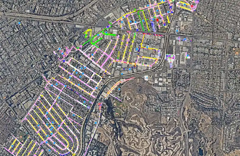
Subsurface Damage Prevention

BEFORE YOU BUILD, CUT, CORE, OR DIG, CALL GPRS

When it comes to construction and facility management, every decision you make can cost time, money, and even lives. GPRS is in pursuit of a world with 100% subsurface damage prevention. Our 99.8% accuracy rate for ground penetrating radar services (GPR), utility locating services, utility mapping services, and concrete scanning services will locate critical targets like underground utilities, post tension cables, rebar, conduits, underground storage tanks (USTs), and more to help keep your project on time, on budget, and safe. Our NASSCO-certified CCTV video pipe inspection & leak detection services find pipe defects, blockages, and leaks with pinpoint accuracy.

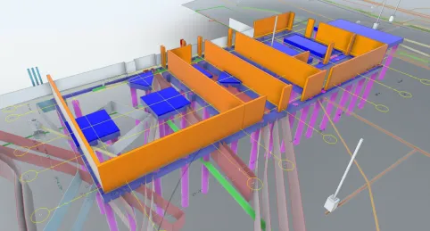
Existing Conditions Documentation

ACCESS ACCURATE AS-BUILTS WITH OUR INFRASTRUCTURE MAPPING & MODELING SERVICES

When record drawings do not match the as-built conditions, general contractors and facility managers are at risk of avoidable change orders, delays, budget overruns, and even damage or injuries. Let GPRS’ in-house team create an as-built (TruBuilt) for your project – showing actual existing conditions above or below ground… or both. Our 3D Laser Scanning, reality capture services, and 3D Photogrammetry services deliver up-to-date and accurate construction as-builts, existing condition drawings, 2D CAD drawings, 3D BIM models, 3D mesh models, digital twins, point clouds, updated floorplans (FLRPLN), and more for construction design, prefabrication, clash detection, facility modifications, and asset management.

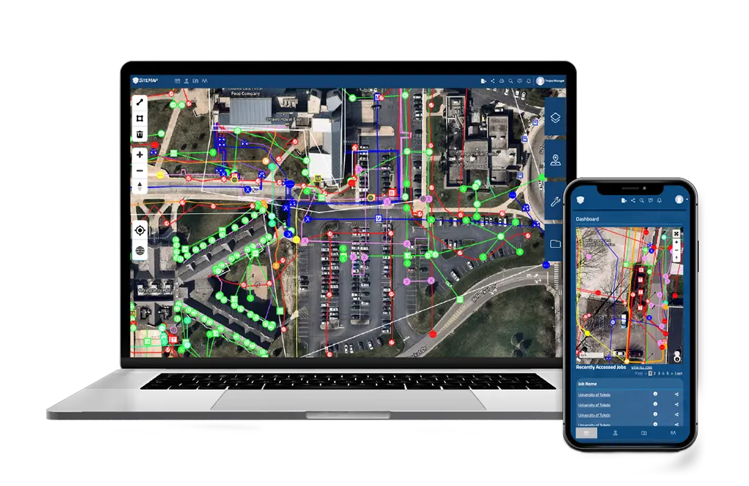
Facility & Project Management

STORE, MANAGE & SHARE PROJECT DATA WITH YOUR TEAM

Better manage your job site or facility with our GIS software platform, SiteMap®. SiteMap®(patent pending) allows you to quickly access, view, and share your infrastructure data securely with subcontractors, engineers, and your team. All of your utility, structural, water & sewer, and facility information is uploaded into the SiteMap® Map Viewer and Digital Plan Room. You can document construction progress with our Progressive Capture (ProCap) service which utilizes 3D photogrammetry or 3D laser scanning to track the evolution of the site and document key project milestones. Virtual Tours like WalkThru 3D allow you to virtually walk-through a site or facility in minutes, take basic measurements, estimate clearances and distances, and add digital notes.

UNIVERSITY OF TOLEDO
Case Study

GPRS is providing our 99.8% accurate utility locating and mapping to UToledo’s campus in exchange for field training for our Project Managers.

SiteMap®
Solutions

SiteMap® provides infrastructure information management tailored to meet your organizational needs. Whether you need a single layered utility map or to manage a nationally distributed portfolio, there's a SiteMap® solution for you.

See how GPRS & SiteMap® are already creating safer jobsites, eliminating change orders and budget overruns, and ushering in the future of the construction industry and facility data management by Intelligently Visualizing the Built World™.

 What can we help you visualize?

FIND A PROJECT MANAGER NEAR ME

GPRS SERVICES

Learn More
Illustration of Underground Utility Locating

UTILITY LOCATING Services

Private utility locating is vital to any construction, excavation, or renovation project. 811 One Call services locate public utility lines, but do not typically locate private utilities. GPRS is private utility locating company that employs Ground Penetrating Radar (GPR), electromagnetic locators, CCTV video cameras, acoustic water leak locators and other equipment to scan for subsurface utilities, including depths and GPS mapping, saving time, money, and even lives by avoiding utility strikes to protect all site employees and contractors from potential line strike damages. GPRS provides complimentary .KMZ files for all of our exterior utility locating projects. Our utility mapping services can create an updated as-built drawing for your campus or facility. GPR services can also be used to locate underground storage tanks (USTs), unknown utilities, and even manholes and well heads.
Learn More
Illustration of Subsurface Pipeline Locating

cctv VIDEO PIPE INSPECTION

The majority of sewer pipe defects occur underground in buried pipes that can only be accessed by excavation or CCTV cameras via a Video Pipe Inspection (VPI). GPRS deploys both robotic crawler CCTV pipe cameras and lateral launch cameras to document and assess water systems, drains, and conduct sewer camera inspection services without costly excavation. Our NASSCO-certified WinCan video pipeline inspection reports provide clients the exact location and map of each defect, cross-referenced and tagged with a defect severity level. A CCTV sewer pipe inspection service allows our clients to visualize every inch of water and sewer pipe within their system and to create comprehensive repair and maintenance plans to repair pipe damage in the most cost-effective manner possible.
Learn More
Illustration of Post-tension Concrete With Utility Lines

CONCRETE SCANNING

Any project involving post-tension or slab-on-grade concrete contains an inherent risk of costly damage and/or injury when you core or cut into the slab. Rebar, conduit, and post-tension cables pose significant strike risks, and each has its own unique GPR imaging signature. GPRS’ concrete scanning service provides digital concrete scanning with ground penetrating radar (GPR) to accurately pinpoint the location of each hazard and map it in detail, so there is never a question of where you can cut and where you can’t. Unlike concrete x-ray services, GPR concrete imaging does not require you to close off sections of your site to avoid radiation. In most cases, your work can continue while we scan and locate slab reinforcement and conduits with 99.8%+ accuracy, so that you can safely cut and drill.

GPRS guarantees our accuracy and your safety with our exclusive Green Box Guarantee. Read about our Green Box Guarantee
Learn More

3D LASER SCANNING

GPRS 3D laser scanning services, 3D photogrammetry services, and scan-to-BIM services document the as-built conditions of your building, facility, and site with 2-6 millimeter accuracy. Our reality capture company provides professional 3D scanning services with Leica laser scanners and Matterport cameras.
Architectural, structural, MEP, utility locating, and concrete scanning data is captured with LiDAR technology in the form of a point cloud and can be transformed into custom as-built drawings, 2D CAD drawings, 2D floor plans, utility maps, 3D BIM models, Revit models, 3D mesh models, TruViews, digital twins, 3D virtual tours, and more.
Our 3D scanning company delivers accurate as-builts, maps, and models for architecture, engineering, construction, renovation, oil and gas, historical preservation, industrial, manufacturing, education, healthcare, power, water treatment plant, energy, and utility companies.
Learn More
Illustration of Locating an Item on a Map

mapping & BIM modeling

Complete facility visualization is impossible without accurate documentation. That’s why GPRS provides complimentary high-resolution maps in the form of PDF, KMZ, and SHP files with every outdoor utility locating project we perform.

‍We offer fully integrated reality capture with 3D laser scanning, concrete scanning, outdoor and interior utility locating, Video Pipenspection via CCTV, and drone imagery to provide point clouds, 2D & 3D CAD drawings, 3D BIM models, 3D mesh models, photogrammetry, and customized 3D BIM model walkthroughs, depending on our clients’ needs.

We are the only company able to provide complete top-down imaging, mapping, and modeling of any facility, above and below ground to fully Intelligently Visualize The Built World™ for our clients nationwide.
Learn More
Illustration of Leaking Underground Pipe

LEAK DETECTION Services

GPRS Water Leak Detection Services can quickly pinpoint a known water leak when a problem is identified in municipal water or sewer infrastructure or for an industrial facility. We can also proactively search for leaks in domestic water and fire systems, water main leak detection, and complete Water Loss Surveys to locate problems before they are evident and costly. Underground water leak detection services can save you time, money, and precious water.
Acoustic leak detection is aided by leak correlation to provide accurate, real-time verification of an active leak and can be integrated with our CCTV Video Pipe Inspection Services and utility locating services to improve commercial, industrial, and municipal water infrastructure efficiency, and avoid unnecessary excavation. At GPRS we are the best leak detection company in the industry because we are backed by the power of our 99.8% accurate underground utility locating process.
Green Box Guarantee Logo
When GPRS places a green box within a layout prior to cutting or coring concrete, we guarantee that area to be free of obstructions.
GPRS - Utility scanning image

What is ground penetrating radar?

You cannot avoid what you cannot see. Ground Penetrating Radar (GPR) is a non-invasive locating tool that allows our SIM-Certified Project Managers to scan post-tension concrete for conduit, rebar, and other encased objects, and to effectively locate utility lines, water and sewer pipes, telecom and fiberoptic cables, and subsurface voids.

GPR functions by sending radar signals into a surface like concrete or soil and capturing that signal as it bounces back to create a specific reading that allows our highly trained Project Managers to determine the length, depth, and type of subsurface feature located.

The various location features can then be marked out on the surface to show the precise location and provide clear boundaries and spaces where you can cut, drill, or excavate safely.

RISK MANAGEMENT

Complete facility visualization can almost eliminate clashes, reworks, change orders, and the cost overruns associated with them. 

GPRS is committed to helping you manage and mitigate risk on your job and for your team. We provide complete facility infrastructure visualization through utility locating, concrete scanning & imaging, 3D laser scanning, video pipe inspection, leak detection, drone photogrammetry, and state-of-the-art mapping & modeling services so that you and your team can see potential hazards and design obstacles and mitigate risk to keep your project on time, on budget, and most importantly, safe.

Our goal is 100% subsurface damage prevention, and we have achieved and maintained a 99.8% accuracy rate in concrete scanning & imaging and underground utility locating on more than 400,000 jobs and counting. 

When underground utilities and subsurface features are not accurately located prior to excavation or trenching, your most important asset is at risk – your people. 

When you call GPRS, we use the latest in locating and scanning technology to make sure that we help keep your people, and ours, safe.

GPRS INDUSTRY EXPERTISE

power trasmission & distribution
Power Transmission & Distribution
Learn More
Telecom
Learn More
Renewable Energy
Learn More
Oil & Gas
Learn More
Power Generation
Learn More
Facilities
Learn More
One Call
Learn More
Environmental
Learn More
Civil, Road & Bridge
Learn More
Design Builds & Remodels
Learn More
Education
Learn More
Retail & Restaurant Construction
Learn More
Water & Sewer
Learn More
Engineering & Surveying
Coming Soon
Electric Vehicle Charging Icon | GPRS Images
Electric Vehicle Charging
Learn More
Safety Tour Of America  | GPRS Images

Safety Tour Of America

We crisscrossed the nation to speak with our partners in safety to hear firsthand from them how they consistently do their jobs at such an elite level. We spoke with safety directors, project managers, executives, and other safety professionals from 11 of our valued partners in the inaugural leg of this tour.